Modern wind resource models are more powerful than ever. Today, developers can access decades of atmospheric reanalysis data, high-resolution terrain models, and sophisticated numerical weather simulations covering almost any location on Earth. With so much information available, a natural question arises:
If the models are already so advanced, why do local measurements still matter?
The answer is simple: no model can observe what is happening at your site.
The map and the territory
Imagine planning a journey using a detailed map. The map shows every road, hill, and river, but it cannot tell you about the roadworks that started yesterday or the traffic jam around the next corner. Wind models face a similar challenge.
Modern atmospheric simulations can reproduce large-scale weather patterns remarkably well, but every site has unique local characteristics. A ridge may accelerate the wind more than expected, while nearby terrain features can generate turbulence. Local roughness changes can influence the wind resource in ways that are difficult to capture perfectly, even for a high-resolution model. The model provides the big picture. Measurements provide the local reality.
In regions such as the Persian Gulf and the broader Middle East, local atmospheric and surface characteristics can strongly influence wind patterns. Coastal circulations, thermal gradients, atmospheric stability, and desert surface conditions contribute to spatial variability that benefits from local refinement. By integrating observational data, the wind resource assessment can be further optimized, providing greater confidence in site-specific analyses.
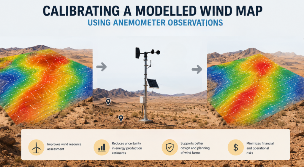
Why calibration works
Meteorological masts and LiDAR systems record the wind directly at the site. They capture the local conditions that make each project unique. Calibration combines these measurements with long-term atmospheric simulations. Rather than replacing the model, the measurements help refine it. The result is a dataset that preserves the long-term climate information from the simulation while incorporating the site’s observed behaviour. This approach takes advantage of the strengths of both sources:
Long-term consistency from atmospheric modelling.
Local accuracy from on-site observations.
Neither source alone can provide the complete picture.
Looking beyond the measurement period
A measurement campaign may last one, two, or three years. A wind farm, however, is expected to operate for more than twenty years. This creates a challenge. Developers need to understand not only the wind observed during the campaign, but also how those measurements relate to the long-term climate.
Calibration helps bridge that gap. By linking local observations to long-term simulations, it becomes possible to assess the representativeness of the measurement period and reduce uncertainty in future energy production estimates. Vortex Remodeling tool allows to extend the short period of measurements to the long term or full lifetime of the project.
Vortex FARM product was validated calibrating with data from a met mast and validating against another met mast located within the FARM extension. The results showed that the calibrated model provided a much better representation of the local wind conditions than the uncalibrated model, leading to more accurate energy production estimates.
A wind farm represents a long-term investment worth tens or hundreds of millions of dollars. In that context, using available measurements to reduce uncertainty is often one of the simplest and most cost-effective improvements that can be made.
At Vortex, any measurement data uploaded for calibration is deleted from our servers after 24 hours, and the calibration results are only shared with the customer. We understand the importance of data privacy and security and are committed to protecting our customers’ information.
The best of both worlds
Wind models provide the long-term perspective. Measurements provide the local truth. Used together, they create a more reliable representation of the wind resource than either source could achieve on its own. At Vortex, calibration is a key part of how we help developers reduce uncertainty and gain greater confidence in their wind resource assessments.

 Want to learn more about how the calibration methodology works and the validation results? Download the full document here!