Close

Reanalysis integrates model data with observations worldwide to create a globally comprehensive and consistent dataset through the application of physical laws. This process, known as data assimilation, mirrors the methodology employed by numerical weather prediction centers. At regular intervals (e.g., every 12 hours at ECMWF), a previous forecast is merged with newly available observations using an optimal approach to generate a refined estimate of the atmospheric state, known as analysis. This analysis serves as the foundation for producing updated and enhanced forecasts.

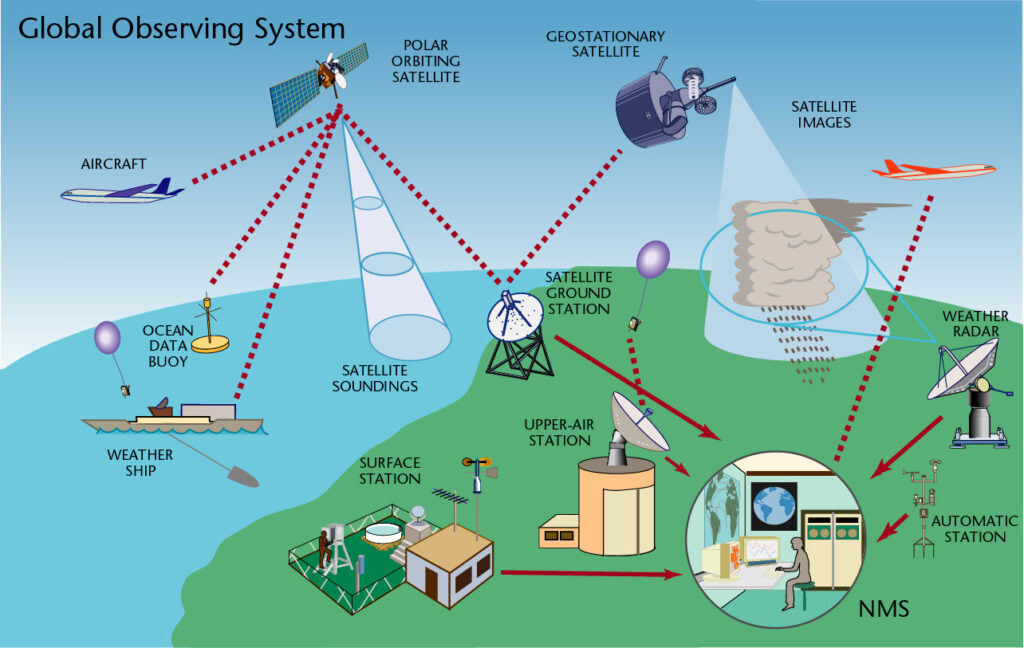
Observation components of the Global Observing System. (Credit: WMO)
Observations have historically been unevenly distributed and prone to errors. Even with advancements in satellite technology, relying solely on observations cannot offer a comprehensive and precise depiction of the Earth’s system worldwide at any given moment. Reanalyses play a crucial role in bridging the gaps in the observational record. They provide consistent temporal coverage, thereby reducing the likelihood of spurious signals of change.
Climate Forecast System Reanalysis (CFSR) was released by the National Centers for Environmental Prediction (NOAA) in 2010. Spatial resolution is 0.5 by 0.5 degrees of latitude and longitude with 37 vertical levels (64 model). The temporal resolution of 6 hours (00, 06, 12 and 18 UTC) extends from 1979 up to the present. Updated daily, with a latency of just one day.
The second Modern-Era Retrospective analysis for Research and Applications (MERRA2) was released by NASA in 2016 to replace MERRA. Spatial resolution is 0.625 degrees of longitude by 0.5 degrees of latitude with 42 vertical levels (72 model). The temporal resolution of 6 hours (00, 06, 12 and 18 UTC) extending from 1980 up to the present, updated monthly with a latency of one and a half months.
The fifth-generation reanalysis by the European Centre for Medium-Range Weather Forecasts (ECMWF) was introduced in 2018, to replace the ERA-Interim reanalysis. It has a spatial resolution is 0.25 by 0.25 degrees of latitude and longitude with 37 vertical levels (137 model). Temporal resolution is hourly extending from 1940 up to the present. Updated daily with a latency of approximately five days, ERA5 ensures timely access to critical data. It’s worth noting that an initial release, referred to as ERA5T, precedes the final version by 2 to 3 months. Any significant discrepancies identified in ERA5T may be rectified in subsequent releases.
| Reanalysis | CFSR | MERRA2 | ERA5 |
|---|---|---|---|
| Issued by | NCEP (NOAA), 2010 | NASA, 2016 | ECWMF, 2018 |
| Spatial resolution (degrees) | 0.5 x 0.5 | 0.5 x 0.625 | 0.25 x 0.25 |
| Vertical levels | 37 | 42 | 37 |
| Temporal resolution | 6h | 6h | Hourly |
| Starting Period | 1979 | 1980 | 1940 |
| Update Frequency | Daily | Monthly | Monthly (ERA5), Daily (ERA5T) |
| Latency | 1 day | Less 2 months | 3 months (ERA5), 5 days (ERA5T) |
Summary of the attributes for each reanalysis dataset
Due to the limited availability of long-term measurements with adequate coverage at heights relevant to wind power applications, reanalysis datasets have become a preferred data source for large-scale wind power analyses. These datasets offer comprehensive coverage over vast geographical areas and extended time periods.
Reanalysis datasets are particularly useful for extending short observation datasets to the long term using correlation techniques such as Measure Correlate Predict (MCP). Additionally, they serve as valuable initial estimates for energy assessments during the early stages of project development, especially during greenfield prospecting.
However, reanalysis data can exhibit a wide range of biases due to the inherent limitations of model resolution. To mitigate this issue, mesoscale modeling techniques are employed to enhance the resolution of coarse reanalysis data. This involves downscaling the native resolution of reanalysis datasets to higher resolutions through the utilization of multiple nested simulations, thereby improving the accuracy and reliability of wind resource assessments.

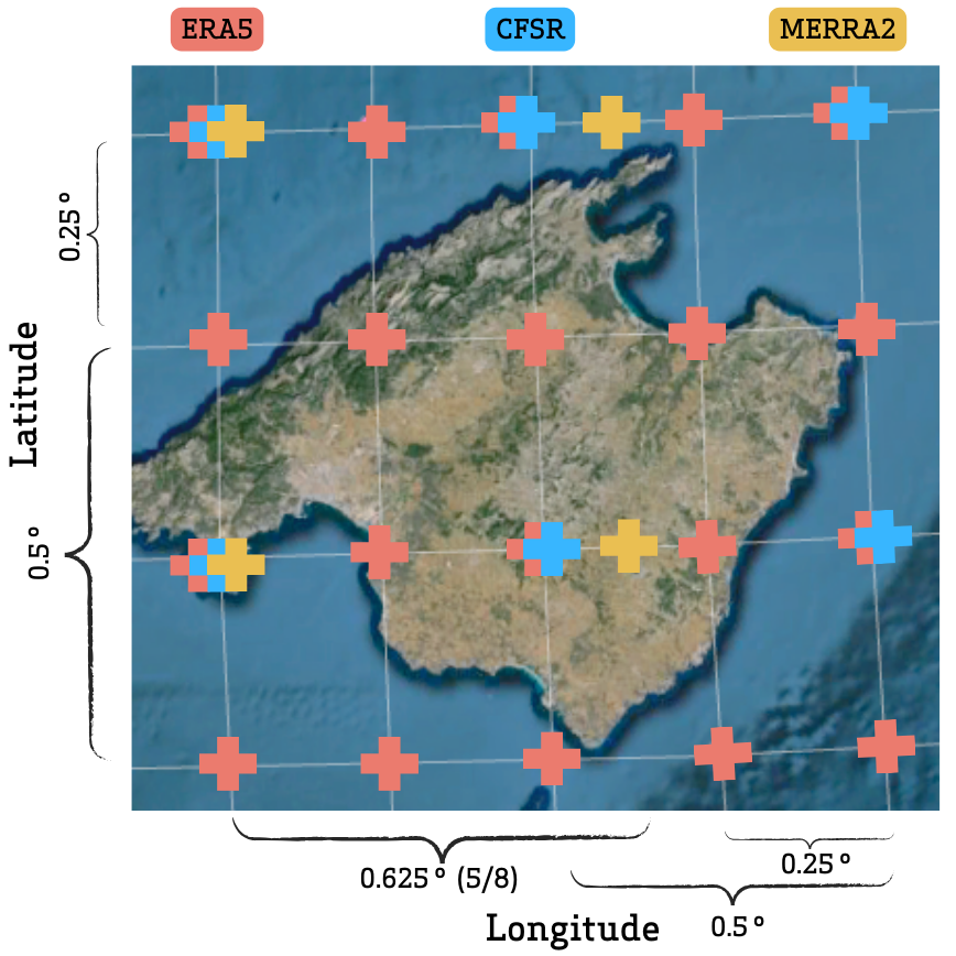
Grid nodes for each reanalysis dataset over the island of Mallorca, which is approximately 100km wide from West to East.
ERA5 exhibits higher resolution and MERRA2 shows an asymmetric grid width.
Modeled wind resource data for the wind industry.
At any site around the world. Onshore and offshore.